How a Border Line Changes the Map Around It
A border line on a map can divide jurisdictions while local routes connect them. Learn to describe the mapped division clearly without mistaking it for local life.
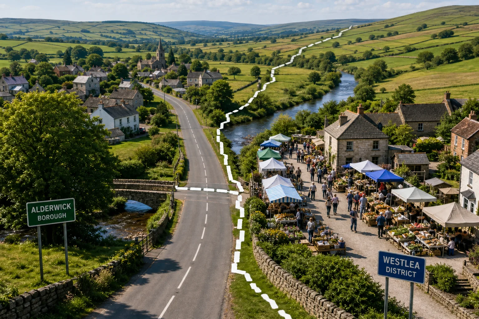
A bold border line on a map of an invented county crosses a road that continues on both sides, while a nearby market serves people from either side. That border line shows a mapped division; it does not, by itself, show where local connections stop.
To describe the line accurately, separate what the map identifies from what it merely places nearby. A boundary can mark an administrative edge without explaining how residents use the road, who runs the market or what rules apply there.
What kind of boundary does the map identify?
Start with the legend, title, date and notes. A line might mark a national frontier, a county edge, a borough boundary or the limit of a protected area. Similar-looking symbols can refer to very different divisions.
Use the map’s wording. If the legend calls the line a borough boundary, describe it that way. If the legend is missing or vague, call it a mapped boundary rather than assigning it a more specific status. A symbol alone cannot establish legal authority or practical effects.
Check whether the notes distinguish an agreed boundary from a claimed or disputed one. A continuous stroke can look decisive, but its appearance does not settle the line’s status. Use the map’s own notes, and consult relevant official records or a qualified professional if the exact legal position matters.
What does the line separate, and what crosses it?
Look at the places and routes on either side. A road, footpath, river crossing or railway may connect areas under different jurisdictions. Two places close together on the map, by contrast, may have no direct route between them.
A map might show a school on one side and nearby homes on the other. That establishes their mapped positions, not who attends the school, how people reach it or whether the boundary affects access.
Local connections can also involve services, shared public spaces and overlapping place names. A regional label may sit beside smaller settlement names, while a map intended for administration may leave those names out. An omission tells you about the map’s coverage, not whether a community exists.
What should you check before describing a border line?
- Legend and notes: If they name a boundary type, use that term; if they do not, describe a mapped boundary and consult another source before specifying its status.
- Routes across the line: If a road or path is drawn continuously, say it crosses the mapped boundary; if it appears to stop, check a more detailed map before saying travel is blocked.
- Nearby services: If a school, clinic or market is labelled, describe its mapped position; if access or provision matters, seek a source that addresses those questions.
- Place names: If names appear on both sides, describe their distribution; if a name is absent, do not infer that the community is absent and look for a map focused on local names.
- Line and landscape: If the line follows a river or ridge, describe that visible alignment; if the scale makes its position unclear, avoid claims about a particular street or property and check a more detailed source.
- Colour and shading: If the key explains a colour change, state which areas it distinguishes; if the key is unavailable, do not assign the colour a meaning and consult the map’s notes or source.
- Date and scale: If both are provided, include them when comparing maps; if either is missing, treat apparent differences cautiously and find a dated map at a suitable level of detail.
Each check leads to a choice: describe what the map supports, or seek a source suited to the question it leaves open. That keeps the boundary from standing in for a fuller account of local relationships.
How do labels, line style and scale shape the picture?
A thick, continuous stroke can dominate the page, while a broken line or note may indicate a different kind of boundary. Compare the symbol with roads, rivers and settlement labels. A map’s visual emphasis may make the administrative edge more noticeable than the routes that cross it.
Labels also direct attention. A large regional name can overshadow a smaller settlement, and a colour change can make an administrative division look like a natural break in the landscape. Neither tells you how residents identify or which connections matter most to them.
Scale affects apparent precision. A broad map may simplify a winding boundary; a closer view may make it appear to pass through a street. Treat that as a prompt to consult a more detailed source, not as a finding about ownership or rights. The boundary is like a frame around a window: it directs your view without explaining everything beyond it.
What questions can a border map answer?
Why might the same boundary look different on two maps?
Maps may use different colours, line styles or levels of detail, or depict different boundary types. Compare each legend, date and stated source before deciding whether they show the same division.
Does a boundary line show how residents identify?
No; it shows a mapped division, not a shared view of identity. If identity matters, seek local accounts and state whose perspective each account represents.
Can a road or river establish a boundary’s legal meaning?
Not by appearance alone. A map may place the line beside or across a feature, but questions about its legal position or effects call for relevant official records or qualified advice.
What if a nearby community is not labelled?
Say that the map does not label it rather than implying that it is absent. A map focused on local names or settlement patterns may offer more context.
How can you describe the map without overclaiming?
Say an invented map of Alderwick, a fictional borough, has a legend identifying a bold line as the borough boundary. The road crosses the line and is drawn continuously on both sides; the shared market is labelled beside it. The map does not say who runs the market or whether rules change at the boundary.
First, call the line a borough boundary because the legend does. Then describe the road as crossing it and the market as nearby. Leave out claims about access, market management or traders’ identities because the map supplies no evidence for them. The description is precise about the mapped relationship without pretending the boundary has no effect.
A border line on a map distinguishes the areas shown, while roads, services and shared places may connect them. For a clear account, name the boundary the map identifies, describe its relationship to those connections, and use official records or local sources for questions about legal effects or lived experience.
Nearby readings
Why North Sits at the Top of So Many Maps
Why north sits at the top of maps: understand how this familiar convention developed and decide…
Map Legend Design: Read the Symbols Before You Follow Them
Map legend design helps you interpret symbols, compare categories and spot marks that need checking before…