How to Read Street Signs at a Confusing Junction
Learn how to read street signs at a confusing junction by linking each arrow to its road name and destination before choosing your branch.
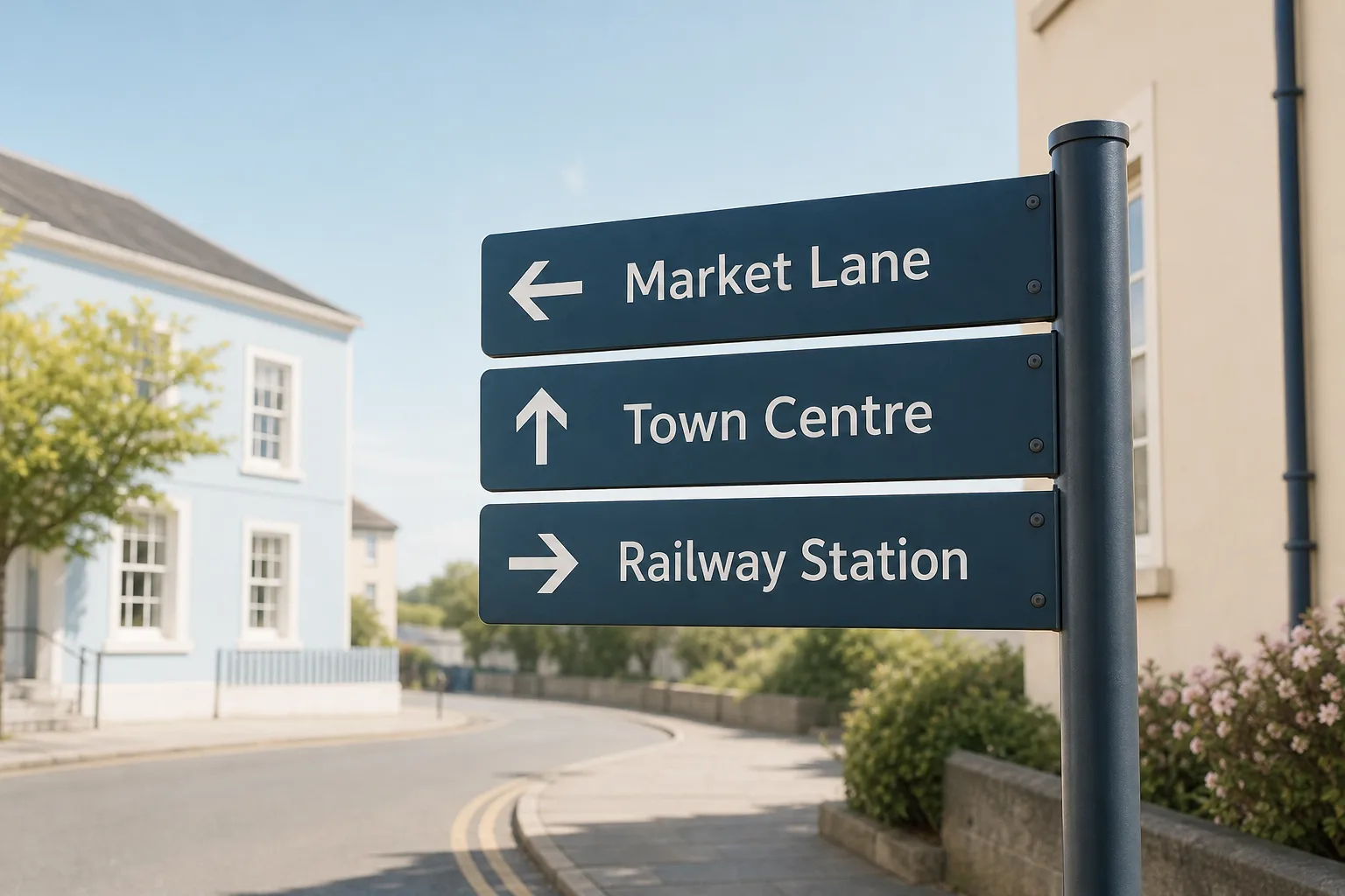
Learn how to read street signs at a confusing junction by linking each arrow to its road name and destination before choosing your branch.
Wayfinding · 5 min read
You are walking towards a junction when a sign offers three choices: a named street, a town centre and a railway station. To read street signs at a confusing junction, match each arrow to its label, then decide which label answers the question your route raises.
The useful distinction is between a road, a direction and a destination. A road name identifies a street; an arrow shows which branch it follows; a destination points towards a larger place that may be several turns away. Keeping those jobs separate helps prevent a prominent destination from distracting you from the street you actually need.
Link each arrow to its own label
Read the sign from its layout, not from whichever words catch your eye first. Find a label, then trace its line or position to the arrowhead. On a crowded panel, arrows may point straight ahead, diagonally or sharply aside, so do not assume that the nearest-looking arrow belongs to the nearest-looking name.
Check whether the panel groups information by branch. A street name beside a left-pointing arrow usually identifies the road reached by taking that branch. A destination below it may describe where that road leads, rather than name the next street. If the sign has several panels, read each panel as a unit before comparing their directions.
Choose the clue that fits your next decision
Start with the instruction you need to act on now. If it names a street, find that street on the sign. If it names a place, look for the destination label. Then use the arrow to identify the branch. This order keeps the sign’s information tied to the route rather than treating every label as equally relevant.
- Observation: Your directions name the next street, and that name appears beside one arrow. If the arrow points to a branch that matches the route, then choose it; otherwise check whether the name appears on another line or panel before moving.
- Observation: Your immediate target is a station or other named place, and the sign shows it as a destination. If its arrow fits the route you are following, then use that branch; otherwise look for a street name or local direction that clarifies the mismatch.
- Observation: One label appears to serve more than one arrow. If the junction map or diagram distinguishes the branches, then use that distinction; otherwise do not guess between them—seek a clearer sign or local direction.
- Observation: The sign names a destination but not the street your directions specify. If the destination is consistent with the route, then treat it as confirmation only; otherwise pause and check the next instruction on a current map.
- Observation: The street name matches but the arrow seems to point away from the expected branch. If the sign layout clearly pairs that name with a different arrow, then follow the printed pairing only when it also fits your route; otherwise stop somewhere safe and ask for local guidance.
- Observation: A destination label appears to continue beyond the junction. If your route is for that broad destination, then follow its arrow and check the next junction instruction; otherwise use the named street for the immediate turn.
Compare sign wording with your route
A map and a street sign may describe the same area in different ways. Your map might name a road while the sign points towards a district or landmark. Look for a shared clue in the route instruction, such as the next street name or a destination you already recognise. Do not treat different wording as proof that the sign is wrong.
Also distinguish the next road from the eventual destination. A town-centre label may guide you through several streets; it does not necessarily name the road immediately beyond the junction. If another turn follows soon, keep that next instruction in mind rather than assuming the destination label settles every choice.
What should you check when the sign is ambiguous?
What if one street name appears with two arrows?
Check the sign’s layout to see whether the street divides into branches or whether one name belongs to a neighbouring line. If the distinction is still unclear, use a junction diagram or ask for local directions instead of choosing at random.
Does a destination label name the next street?
Usually, it indicates a route towards a place, not necessarily the next road. Read it alongside the street name and arrow to identify the immediate branch.
What if the sign does not repeat the wording on your map?
Look for another shared clue, such as the next named street or a recognisable destination. If the route remains uncertain, check a current map or ask someone nearby before proceeding.
Which clue matters most for a walking route?
Use the street name when your directions specify a street, and a destination label when your immediate target is a named place. In either case, the arrow tells you which branch the sign associates with that clue.
Work through a junction with competing labels
Imagine you are walking to a library on Market Lane. Your directions say to take Market Lane at the next junction, while the sign lists Market Lane with a left arrow and Town Centre with a straight-ahead arrow. First, match the Market Lane label to its left-pointing arrow. Next, check the route instruction for the named street rather than substituting the broader Town Centre destination. The resulting choice is the left branch; if the sign’s layout did not clearly pair Market Lane with that arrow, the sensible decision would be to stop and seek clearer guidance.
When the sign is hard to scan, return to the immediate question: which named road or destination does your route require? Pair that clue with its arrow, and treat the remaining labels as supporting information rather than competing instructions.
Nearby ideas
Why North Sits at the Top of So Many Maps
Why north sits at the top of maps: understand how this familiar convention developed and decide…
How to Read a Transit Map Legend Before You Choose a Route
Learn how to read a transit map legend and distinguish routes, branches and transfers before you…