Why North Sits at the Top of So Many Maps
Why north sits at the top of maps: understand how this familiar convention developed and decide when a different orientation makes a route easier to read.
Why north sits at the top of maps: understand how this familiar convention developed and decide when a different orientation makes a route easier to read.
Map History · 5 min read
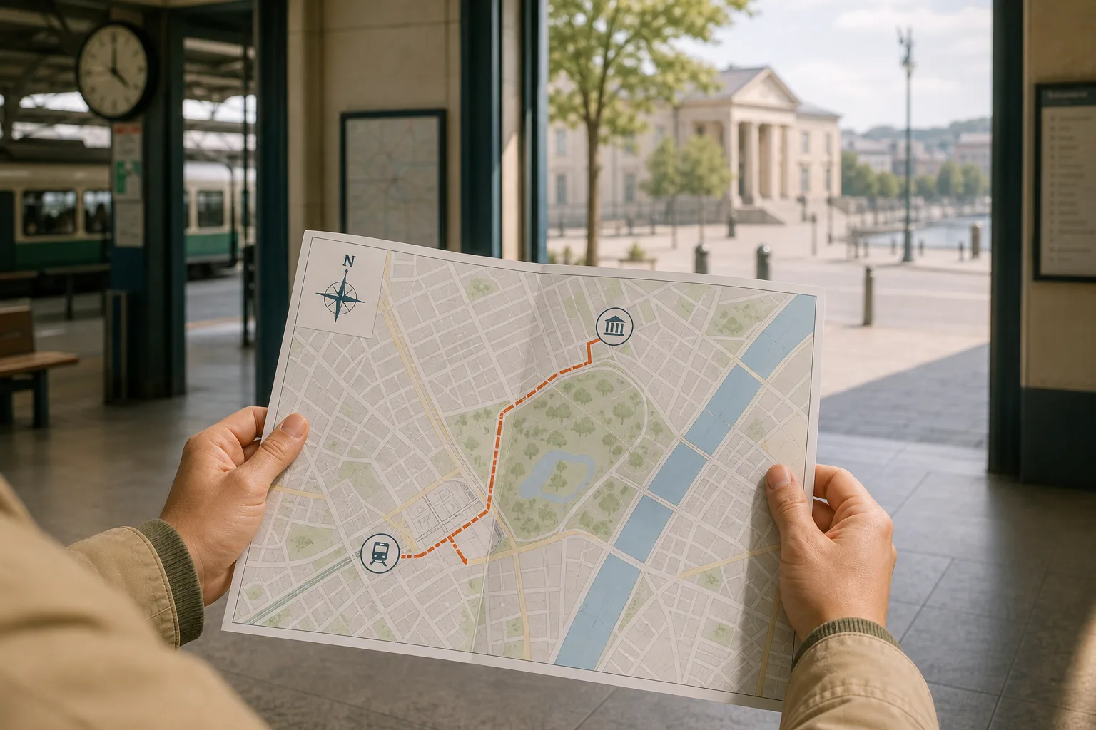
At a station entrance, someone unfolds a street map and turns the paper until the road ahead runs towards the top of the page. North-up is the familiar default on many maps, but it is a convention, not a natural top edge. Its history is best understood through the different purposes maps served and the practical value of a shared orientation.
North-up gives maps a common frame
A map places the curved surface of the Earth on a flat page or screen. The world itself has no top edge. On a north-up map, north is at the top, east at the right, south at the bottom and west at the left.
That shared frame helps readers compare places and talk about direction without first turning the page to match their viewpoint. It is a design choice, not a rule about which way a map must face.
Look for a north arrow or compass rose before assuming the top of a map means north. A map may instead be turned to foreground a coastline, route or central place. Labels can also be angled for readability without changing the map’s orientation.
Mapmakers used the top edge to express different priorities
Maps made for different audiences and purposes did not always put north at the top. Some medieval European world maps placed east at the top, a choice associated with religious ideas and the direction of sunrise. Other maps could be arranged around a ruler’s seat, a route, a coastline or a locally important landmark.
These choices remind us that a map’s orientation can help explain what its maker wanted readers to notice. A map centred on a town, for instance, might make that place the visual anchor rather than follow a universal compass direction.
Compass use offered navigators a way to establish direction, although a magnetic compass indicates magnetic north rather than true north. Maps and charts made for navigation had their own practical demands; they should not be treated as evidence that every mapmaker adopted north-up at the same time.
Printing made a shared orientation useful
Printed maps could circulate beyond the people who made them. A consistent frame helped readers compare sheets, interpret a compass rose and locate places in relation to one another. North-up was convenient to reproduce and recognise, but it was not the only layout that could serve a map’s purpose.
Repeated exposure also made the arrangement familiar. School atlases and road maps often used north-up, so readers learnt to expect north at the top. That familiarity can make another orientation seem unusual even when it suits the task better.
Orientation is only one part of a map’s design. A bold boundary, a prominent city label or a large title can draw the eye regardless of which direction sits at the top.
Choose an orientation that suits the route
North-up is useful for comparing locations, following compass directions and keeping a broad sense of where places lie. For a close sequence of turns, a track-up or heading-up view can make it easier to match the next street to the direction of travel. The route itself does not change when the page turns.
Imagine you are walking from Alder Station to the fictional Riverside Museum, with a bend around a park between them. On a north-up paper map, the first leg runs down and left from the station, then turns right beside the park. You rotate the map so the next street runs towards the top; the expected result is that the upcoming junction is easier to compare with the road ahead, while north becomes less obvious.
That trade-off matters. A rotated map can help with the next turn but make it harder to compare the route with a second map or explain compass directions to someone else. Use the view that answers the question in front of you, then restore north-up when you need the wider layout.
What should you check before following a map?
How can I tell which way a map is oriented?
Find a north arrow, compass rose or orientation control. If none is visible, compare a recognisable feature, such as a river bend or railway line, with the area around you before treating the page’s top as north.
Does turning a map change the route?
No. Rotating the page changes its position relative to your view, not the streets or route shown. Check landmarks and junctions to confirm which way to go.
When is north-up more useful than heading-up?
Use north-up to compare places, discuss compass directions or understand a broader area. Choose heading-up when matching nearby turns to the direction you are facing.
Why might a map not put north at the top?
A map may be arranged to emphasise a route, coastline, settlement or another feature. Check its orientation symbol rather than inferring direction from the page shape or the angle of its labels.
Use these checks to choose the right frame
- Look for a north arrow: if it points towards the top edge, read the map as north-up; if it points elsewhere, follow the arrow when interpreting directions.
- Check for a compass rose: if its direction labels match the page edges, use those edges to compare locations; if they do not, follow the printed labels instead.
- Compare a known landmark: if a river bend or railway line matches the ground, use it to confirm the map’s orientation; if it does not, pause and check whether the map shows another area or a different view.
- Decide whether you need an overview: if you are comparing neighbourhoods or bearings, keep north-up; if you are matching an upcoming street, turn to heading-up.
- Check the map’s labels: if place names are angled but the compass reference stays fixed, treat the labels as a readability choice; if the reference also turns, reassess the orientation.
- Check a rotating screen: if the map changes direction while you are comparing the wider route, select a fixed north-up view; if you are following the next turn, keep heading-up only while it remains aligned with your direction of travel.
A north-up map is useful because it gives readers a shared frame, not because north belongs at the top of every page. When you search for why north sits at the top of maps, the practical answer is that convention and repeat use made it familiar. Check the map’s own orientation before following its directions, especially when the page or screen has been turned.
Nearby ideas
How to Read a Transit Map Legend Before You Choose a Route
Learn how to read a transit map legend and distinguish routes, branches and transfers before you…
How to Read Street Signs at a Confusing Junction
Learn how to read street signs at a confusing junction by linking each arrow to its…