Why Place-Names Change at the Edge of a Map
Why place-names change at map edges, and how to compare labels so you can tell whether two spellings identify the same place or different features.
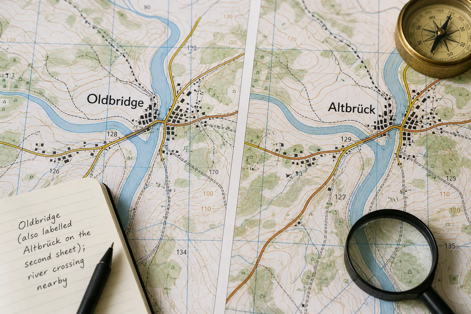
Place-names can change at the edge of a map because adjoining sheets may use different spellings or naming conventions. To compare place-names across map sheets, match the location and the feature first; a difference in letters alone does not tell you whether the names refer to the same place.
Two labels may be alternative names for one settlement, or one may identify a town while the other names its district, historic centre or nearby crossing. Treat the map’s wording as evidence to interpret, not as a verdict about which name is correct.
Why do place-names change between map sheets?
Maps can reflect different languages, writing systems and editorial choices. A name may appear in a local-language form on one sheet and a form familiar to readers of another language on its neighbour. Accents, hyphens and transliteration—the rendering of a name in another writing system—can also vary.
Maps may draw on different gazetteers, official naming guidance or local records, and their conventions can change between editions. A sheet edge gives you a useful point of comparison, but it does not by itself establish why a label differs or which form a naming authority prefers.
For precise classification, consult the relevant national or regional naming authority, especially where official, historical or administrative use matters. Terms such as endonym and exonym are used in naming practice, but definitions and application can vary between authorities; avoid assigning either label solely from the language of the map.
How can you tell if two labels identify the same place?
Begin with the physical setting. Compare a river bend, road junction, coastline or ridge, then check what each label points to. A settlement, the municipality around it and a bridge beside it may all carry different names while occupying the same general area.
Next, compare the feature type and the mapped extent. Settlement shading, boundary lines, symbols and an index can help distinguish a town from its wider administrative area. A label placed near a crossing may name the settlement rather than the bridge, so do not infer the feature from proximity alone.
A map label is like a tag on a drawer: useful for identification, but not a substitute for checking what the drawer contains. Read the label alongside the mapped feature, rather than treating spelling as a complete description.
What should you compare across map sheets?
- Position: If both labels sit by the same river bend or road junction, treat them as a possible match and compare another landmark; if the landmarks differ, keep the identification open and check a wider area.
- Feature type: If both labels refer to settlements, compare their mapped extent; if one names a district and the other a town, record them as related but distinct.
- Language or script guidance: If an authority or map explicitly explains transliteration or spelling, use that guidance to interpret the variant; if no guidance is available, preserve both forms without classifying them.
- Publication date: If the sheets come from different periods, check a current local map or gazetteer when current naming matters; if their dates are similar, compare the authorities or sources cited by each.
- Map purpose and detail: If both sheets show comparable kinds of places, compare their labels directly; if one is a tourist map and the other a topographic sheet, allow for different selection and placement choices.
- Nearby labels: If several names vary in the same area, consider whether the sheets follow different language or naming conventions; if only one differs, check for a local variant, an older form or a different feature.
- Feature boundaries: If a boundary or settlement shading changes around the label, check whether the maps define the named area differently; if no boundary is shown, avoid assuming the label describes a precisely bounded place.
Say your walking note names “Oldbridge”, and one sheet prints that form beside a river crossing. A second sheet prints “Altbrück” near what appears to be the same crossing. You compare the road junction and river bend, then check the second sheet’s index, which identifies its label as a settlement rather than a bridge. For the note, you write “Oldbridge (also labelled Altbrück on the second sheet); river crossing nearby”. The result keeps both map forms tied to their sources and avoids mistaking the settlement for the bridge; the trade-off is a longer note.
Why might one map show a name and another omit it?
Maps have different scales, purposes and room for labels. A regional map may leave out a neighbourhood or small feature that appears on a town plan, while a map designed for visitors may select names differently from a topographic sheet. An absent label alone does not establish that a place no longer exists.
Placement matters too. A long name may be difficult to fit beside roads, symbols or the sheet edge. Before treating an omission as evidence, check another map or gazetteer and make sure both sheets cover the same feature and area.
Which questions help resolve place-name differences?
What do endonym and exonym mean?
These terms describe kinds of place-name forms, but their definitions and use depend on the relevant naming authority. Check that authority’s guidance before applying either term to a particular label.
Why do accents or letters differ?
A map may render a name in another script or follow a different spelling convention. Compare the full label, its location and any explicit transliteration guidance instead of relying on a simplified spelling alone.
Can two labels refer to different parts of one place?
Yes. A municipality, its built-up area and its historic centre may be separately identified. Compare boundaries, settlement shading and the index to see what each label denotes.
What if the maps still seem to disagree?
Keep both forms linked to their map sources while you check the feature, dates and relevant naming authority. If the distinction affects an official record or another consequential use, consult the authority responsible for that place rather than silently choosing one form.
How should you record a name that varies across maps?
Write the form used by the map you are following, then add a variant when it will help someone identify the same feature. Include the map title or edition if the difference may matter later. For digital searches, try the exact spelling and, where relevant, a version without accents; a nearby landmark can help distinguish similar names.
To compare place-names across map sheets, match the feature and location before interpreting spelling, and consult the relevant naming authority when formal classification matters. Keeping each variant attached to its source makes a route note clearer without pretending that every naming difference has a single simple explanation.
Nearby readings

Why North Sits at the Top of So Many Maps
Why north sits at the top of maps: understand how this familiar convention developed and decide…
Map Legend Design: Read the Symbols Before You Follow Them
Map legend design helps you interpret symbols, compare categories and spot marks that need checking before…