Map Legend Design: Read the Symbols Before You Follow Them
Map legend design helps you interpret symbols, compare categories and spot marks that need checking before you use a map to make a route or place decision.
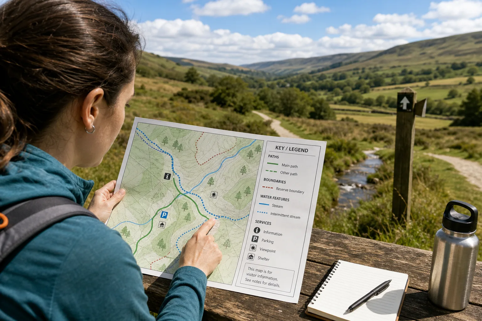
Map legend design determines whether a reader can tell a footpath from a boundary at a glance. Before tracing a route or comparing places, match the marks on the map to the key and check what each symbol actually denotes.
A legend is less a verdict on the landscape than a decoder for one particular map. Its practical value lies in helping you identify features accurately, notice distinctions between similar marks and decide when the map does not provide enough information.
How do you read a map legend efficiently?
Start with the map’s title and purpose, then scan the legend’s headings and labels. A walking map may distinguish paths, access points and services; a geological map may classify rock formations. The same colour or line style can mean different things in different keys, so do not rely on memory alone.
Next, locate each symbol on the map. Compare its shape, colour, line pattern and label with the key. If the symbol changes appearance across the map, check whether the legend gives variants or whether a note explains them. Keep your description close to what is printed: “dashed blue line” is safer than “public route” unless the key says it is one.
What differences should you look for?
Legends often separate features that look similar on the page. A solid and a dashed line might distinguish two kinds of path; different icons might represent separate types of service. Read the exact labels rather than assuming that shared appearance means shared meaning.
Pay attention to grouping, too. A heading such as “services” can collect a clinic, library and public toilet for convenient searching, but it does not make them interchangeable. The category tells you how the map groups those places, not every detail about their use or access.
Think of the legend as a set of labels on kitchen jars: useful for identifying what is inside, but not a description of everything you could cook with it. Treat its categories as a decoding aid, not as extra information the map has not supplied.
How can you check a legend before relying on it?
Use these checks when a symbol or category affects how you interpret the map. Each result points to a clear next move:
Check whether the map title matches your purpose. If it names the subject you need, continue with its legend; if not, choose a map designed for that subject.
Check the symbol’s shape against the key. If the shape matches a labelled entry, use that label; if it does not, look for a note or leave the feature unidentified.
Check line patterns as well as colour. If a solid or dashed style distinguishes categories, follow that distinction; if the pattern is unclear, compare the printed labels or seek a clearer copy.
Check whether the legend groups unlike places under one heading. If the group is broad, use it only as a search category; if you need a specific service or facility, verify the individual place separately.
Check for a date, source note or map-specific explanation. If one clarifies the symbol or coverage, apply that information; if none does, treat uncertain details as unresolved.
Check whether a feature you need appears in the key. If it has a clear entry, use the stated meaning; if it is absent, do not assume it is represented and consult another suitable map or source.
What should you do when a symbol is unclear?
First, check the legend again, including subheadings and notes. Then look for a source line, date or explanatory text elsewhere on the map. Those details may define the map’s coverage or clarify a symbol that is not obvious from its appearance.
If the mark remains uncertain, state what you can observe without turning an interpretation into a fact. For example, describe “a dotted line crossing the stream” rather than calling it a path when the key does not identify it that way. If access or a boundary affects a real decision, check a current source from the relevant local authority or map provider.
Say you have an invented visitor map of a fictional reserve. Its key labels a blue dotted line as a water feature, while the line crosses a path shown in green. You check the notes, find no explanation of the crossing, and record the blue mark as a water feature rather than a route. The resulting decision is to use the green path symbol for route interpretation and leave the crossing’s usability unresolved.
What questions do readers ask about map legends?
Does a map legend explain every feature?
No. Some features may be labelled directly on the map, omitted from the key or outside its stated scope. Check the notes and source information before deciding what an unexplained mark means.
Does the first symbol in the key matter most?
Not necessarily. Its position may reflect an organising choice rather than importance. Compare the symbol with the map’s title and the features you need to identify.
Can the same symbol mean different things on different maps?
Yes. Meaning depends on the specific legend and the map’s conventions. Read the key for each map instead of carrying over an assumption.
What if two colours are hard to tell apart?
Check for another clue, such as line style, shape or a printed label. If none resolves the distinction, keep the category uncertain and use a clearer source when the difference matters.
How can you describe a legend clearly?
Choose one group in the key and trace its symbol across the map. Note where it appears and whether its label or style changes. This gives you a concrete account of how the map represents that feature, without implying that the key explains more than it does.
For a concise description, name the map’s purpose, the category you followed and any unresolved mark. Map legend design is easiest to use when you treat the key as a set of specific symbol definitions: it can tell you what a mark means on that map, while leaving other questions for a different source.
Nearby readings

How to Read a Transit Map Legend Before You Choose a Route
Learn how to read a transit map legend and distinguish routes, branches and transfers before you…
How to Read Contour Lines on a Topographic Map
Learn how to read contour lines on a topographic map and use their spacing and shape…